Advisory: Strong Wind in Taiwan Due to Typhoon Podul
This advisory affects multiple regions across Taiwan, with varying signal levels based on expected wind speeds and gusts.
TAIWAN — On August 13, 2025, the Central Weather Administration issued a red strong wind advisory effective from the morning of August 13 through the morning of August 14. This advisory affects multiple regions across Taiwan, with varying signal levels based on expected wind speeds and gusts.
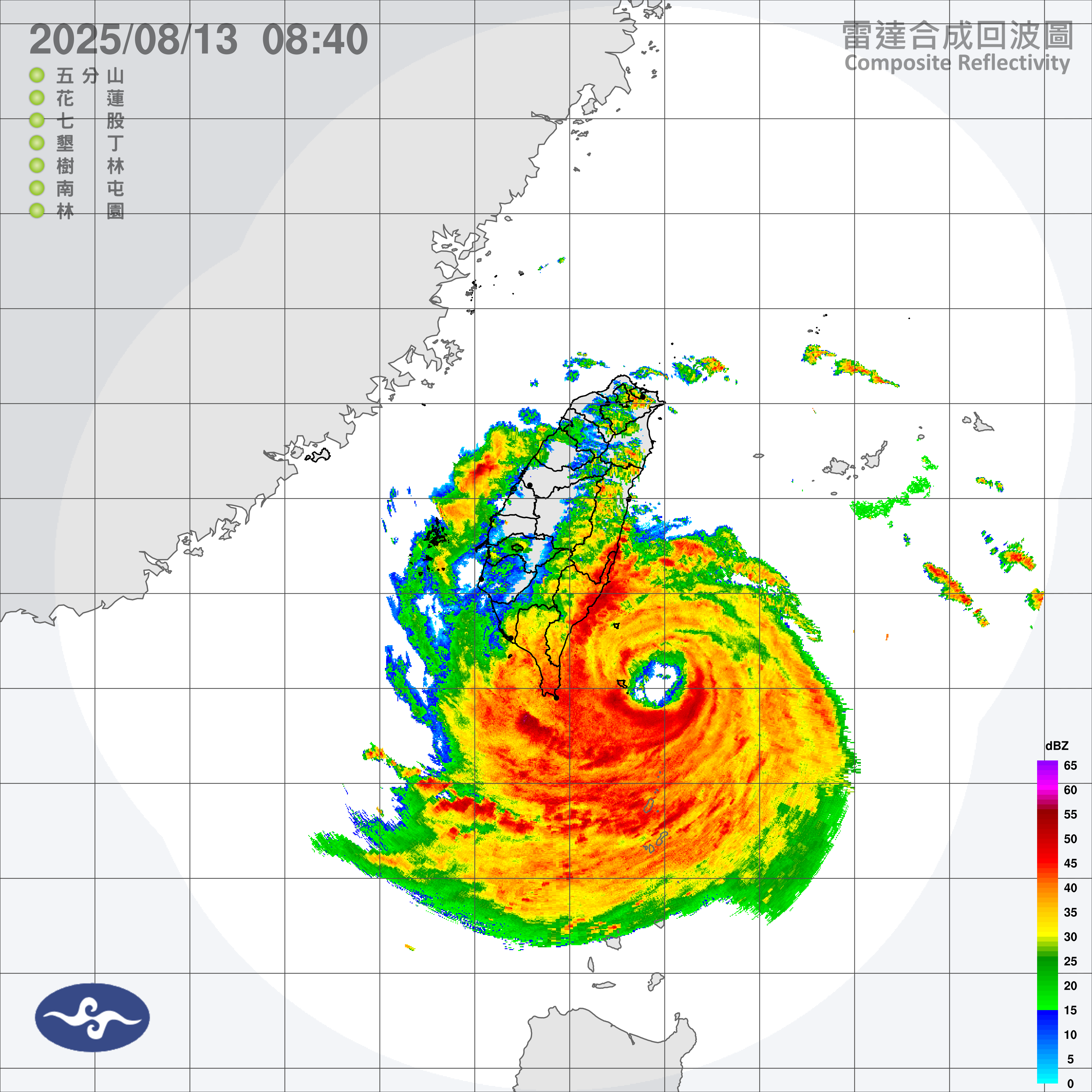
The advisory is linked to Typhoon Podul (202511), positioned at 13000Z on August 13 at 22.0N 122.1E, moving west-northwest at 30 km/h. Minimum pressure is recorded at 945 hPa, with maximum sustained winds near the center at 43 m/s and gusts up to 53 m/s.
Typhoon Podul has intensified as it approaches southern Taiwan, prompting evacuations and shutdowns in affected areas.
Winds extend 180 km in the 15 m/s northwest quadrant, 210 km in the northeast quadrant, 160 km in the southwest quadrant, and 170 km in the southeast quadrant. Heavy rainfall and strong winds are anticipated, particularly in southern and eastern Taiwan, leading to cancellations of hundreds of flights.
Authorities have evacuated thousands from high-risk zones, with impacts expected to persist into mainland China post-landfall.
The storm's path suggests landfall near Taitung City on August 13, with potential for further intensification to a Category 3 typhoon before striking.
PAGASA reports the typhoon affecting extreme northern Luzon with moderate to heavy rain in Batanes and Cagayan. Residents in vulnerable areas are advised to secure outdoor items and avoid unnecessary travel.
Affected Areas and Signal Levels
The strong wind advisory categorizes regions into yellow, orange, and red signals, reflecting average wind speeds and gust thresholds.
Keelung City: Yellow
Taipei City: Yellow
New Taipei City: Yellow
Taoyuan City: Yellow
Hsinchu City: Yellow
Hsinchu County: Yellow
Miaoli County: Yellow
Taichung City: Yellow
Changhua County: Yellow
Nantou County: Yellow
Yunlin County: Orange
Chiayi City: Yellow
Chiayi County: Orange
Tainan City: Orange
Kaohsiung City: Orange
Pingtung County: Orange
Yilan County: Yellow
Hualien County: Orange
Taitung County: Red
Penghu County: Red
Kinmen County: Orange
Lienchiang County: Yellow
Yellow signals apply where average wind speeds reach 10.8 m/s or gusts 17.2 m/s, urging caution for gale winds and potential debris.
Orange signals indicate average speeds of 20.8 m/s or gusts 28.5 m/s, recommending avoidance of outdoor activities due to risks of damage to structures.
Red signals warn of average speeds 32.7 m/s or gusts 41.5 m/s, advising immediate action such as staying indoors and securing breakable items.
Typhoon Forecast and Distribution
Typhoon Podul provides county-level predictions updated every three hours, covering an 18-hour period. In contrast, the land strong wind advisory focuses on distribution for the next day. County-level forecasts serve as the primary reference, with township advisories offering additional insights into wind distribution.
Strong winds in Taiwan commonly occur from October to April due to the northeast monsoon, affecting coastal areas from Tainan northward, the Hengchun Peninsula, Penghu, Ludao, Lanyu, and Matsu.
From May to September, southwesterly winds or typhoons may bring strong winds, potentially extending inland.
Signal Criteria and Reminders
The land strong wind advisory employs a three-tier system based on observed or forecasted wind speeds.
Yellow: Average wind speed reaches 10.8 m/s or gusts reach 17.2 m/s. Caution for strong or gale winds observed or expected (10-minute average wind speed over 10.8 m/s or gusts over 17.2 m/s). Watch out for debris from trees, unstable buildings or fixtures. Outdoor workers should take safety precautions. Firmly secure outdoor items. Reduce driving speed. Be mindful of potential delays in public transportation.
Orange: Average wind speed reaches 20.8 m/s or gusts reach 28.5 m/s. Precautions needed for gale or storm winds observed or expected (10-minute average wind speed over 20.8 m/s or gusts over 28.5 m/s). Warning: Avoid outdoor activities as trees, unstable buildings or fixtures may be damaged or toppled by strong winds and cause harm. Avoid driving. If you're already in a car, find a safe location to pull over and take shelter. Pay attention to announcements of public transportation suspensions and/or reduced speeds on or closure of highways and elevated roads.
Red: Average wind speed reaches 32.7 m/s or gusts reach 41.5 m/s. Take immediate action for hurricane-force winds observed or expected (10-minute average wind speed over 32.7 m/s or gusts over 42.5 m/s). Danger! Move indoors. Stay inside solid buildings and keep away from breakable doors or windows.
Official Statements
"If the criteria are met, the Land Strong Wind Advisory Township Signal is updated at approximately 4:30, 10:30, 16:30, and 22:30 daily (local time), based on the latest forecast and actual strong wind monitoring. During typhoon warnings or special circumstances, updates may occur more frequently." (Central Weather Administration, Typhoon Wind Forecasts).
"Typhoon wind forecasts provide county-level predictions every six hours, updated every three hours, covering an 18-hour period. In contrast, the Land Strong Wind Advisory Township Signal presents strong wind distribution for approximately the next day. County-level forecasts should be the primary reference, with the township advisory offering additional insights into wind distribution." (Central Weather Administration, Advisory Complement to Wind Forecasts During Typhoon Warnings).
"The CWA website provides weather rankings, listing the top 20 locations, times, and stations for average wind and wind gust speeds over the past hour, 24 hours, and current day." (Central Weather Administration, Actual Wind Observations).