
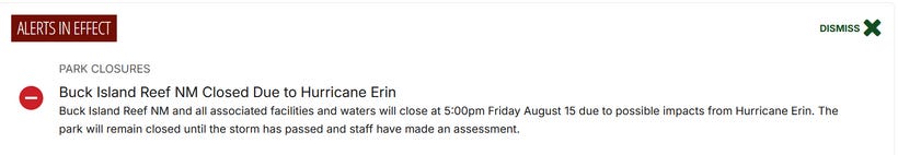
Hurricane Erin Rapidly Intensifies to Category 5, Prompting Coast Guard Port Condition YANKEE in Caribbean
The storm exhibits maximum sustained winds of 160 miles per hour and a minimum central pressure of 915 millibars.


CARIBBEAN — Hurricane Erin has undergone rapid intensification, escalating from a tropical storm to a Category 5 hurricane within 24 hours.


As of August 16, 2025, the storm exhibits maximum sustained winds of 160 miles per hour and a minimum central pressure of 915 millibars. Positioned at 19.8 degrees north latitude and 63.3 degrees west longitude, it moves west at 16 miles per hour.
The system affects the northern Leeward Islands with outer rain bands, while its core remains offshore. In response to the approaching threat, the U.S. Coast Guard has implemented Port Condition YANKEE, restricting vessel movements in affected ports to ensure safety.
The hurricane's path indicates a turn toward the west-northwest, followed by a northward shift early next week. This trajectory positions the center north of the northern Leeward Islands, Virgin Islands, and Puerto Rico through the weekend.
No direct landfall on the United States mainland is anticipated, though hazardous conditions extend to coastal areas. Swells generated by the storm reach portions of the Leeward Islands, Virgin Islands, Puerto Rico, Hispaniola, Turks and Caicos Islands, Bahamas, Bermuda, and the United States East Coast.
Rainfall totals of 2 to 4 inches, with isolated amounts up to 6 inches, are expected across the northern Leeward Islands, Virgin Islands, and Puerto Rico. These conditions may lead to localized flash and urban flooding, along with landslides or mudslides. Tropical storm watches remain in effect for St. Martin, St. Barthelemy, and Sint Maarten.
Life-threatening surf and rip currents pose risks along affected coastlines, extending from Florida to Maine. High surf warnings advise caution near beaches, with potential erosion and dangerous water conditions.
Current Status and Forecast Path
Hurricane Erin marks the first hurricane of the 2025 Atlantic season and the initial system to achieve Category 5 status. Originating from a tropical wave on August 9, developing into a tropical storm on August 11, it intensified rapidly amid favorable environmental conditions.
Warm sea surface temperatures and low wind shear contributed to this escalation, with winds increasing rapidly to 160 miles per hour in a single day.
The storm's compact eye-wall structure supports sustained high intensity, with hurricane-force winds extending 30 miles from the center and tropical-storm-force winds reaching 140 miles outward, mainly to the north of the center.
Forecasts indicate some strengthening possible this afternoon, followed by intensity fluctuations over the weekend, with Erin expected to maintain major hurricane status through at least Sunday. Erin is projected to maintain major hurricane status for at least three days while traversing warm Atlantic waters.
Steering currents guide the hurricane westward initially, with a subtropical ridge weakness allowing a northward recurvature east of the Bahamas.
This path avoids direct United States landfall but positions the system near Bermuda later in the week. Models show consensus on this offshore track, though minor deviations could influence swell impacts. The system is projected to grow significantly in size by mid-next week, potentially doubling or tripling, leading to prolonged rough ocean conditions in the western Atlantic.
Monitoring continues for potential adjustments, as long-range forecasts carry inherent uncertainties. Environmental factors, including increased wind shear, may lead to gradual weakening after the initial peak.
Impacts and Safety Measures
Prior to reaching the Caribbean, Erin caused nine flooding-related deaths, widespread property damage, and the displacement of 1,500 people in Cape Verde on August 11, with rainfall exceeding 7.5 inches in some areas.
Outer bands of Hurricane Erin produce heavy rainfall across the northern Leeward Islands, Virgin Islands, and Puerto Rico, heightening flood risks in urban and low-lying areas. Isolated totals up to 6 inches could trigger flash flooding and mudslides, particularly in hilly terrain. Coastal flooding remains a concern where onshore winds persist.
The United States Coast Guard has set Port Condition YANKEE for seaports in the United States Virgin Islands and Puerto Rico, effective August 15 and 16, 2025, respectively. This restricts inbound vessel traffic and requires ocean-going vessels over 500 gross tons to depart or secure moorings.
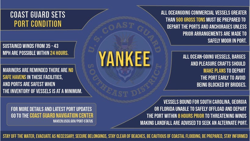
Ports in Arecibo, San Juan, Fajardo, Ceiba, Vieques, and Culebra, Puerto Rico, along with St. Thomas and St. John, United States Virgin Islands, operate under these conditions.
Safety advisories emphasize securing belongings, avoiding beaches, and preparing for coastal flooding. Residents should develop family plans, assemble disaster supply kits, and monitor progress via local media and VHF radio channel 16. Swimmers face heightened dangers from strong waves and rip currents.
Federal Emergency Management Agency personnel, exceeding 200 workers, have deployed to Puerto Rico in anticipation of needs. Flood watches cover the territory, with preparations for potential landfall effects.
Projections and Analysis
 | A guest post by
|