Hurricane Melissa: Category 5 Intensity in Central Caribbean Sea with Projected Jamaica Landfall
The hurricane is maintaining maximum sustained winds of 175 mph (282 kilometers per hour) and a minimum central pressure of 906 millibars.
CARIBBEAN — The National Hurricane Center issued Advisory 25 at 1500 UTC on October 27. Hurricane Melissa has reached Category 5 status. It maintains maximum sustained winds of 175 mph (282 kilometers per hour) and a minimum central pressure of 906 millibars.
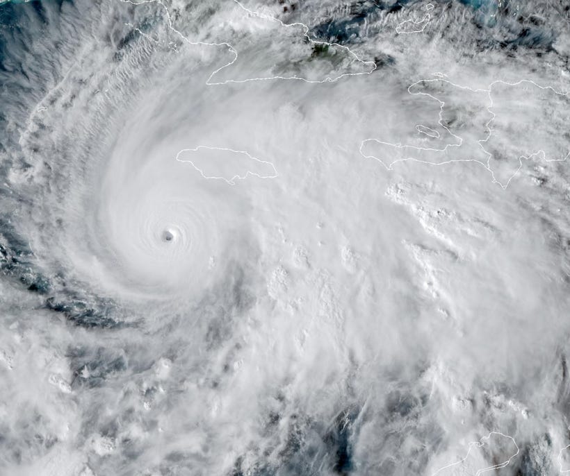
The center is located at 16.5 degrees north latitude and 78.3 degrees west longitude (approximately 110 miles or 177 kilometers south of Kingston, Jamaica). The storm advances west-northwest at 3 mph (5 kilometers per hour) across the central Caribbean Sea.
Hurricane-force winds extend outward up to 25 miles (40 kilometers) from the center. Tropical-storm-force winds span up to 175 miles (280 kilometers).
A hurricane watch continues for Jamaica and southern Hispaniola, encompassing the Dominican Republic. Authorities sustain high alerts in 24 provinces and the National District. They emphasize risks from heavy rainfall and flooding given the storm’s gradual progression.
Melissa’s slow movement heightens the potential for prolonged heavy rain in impacted zones. Projections indicate 15 to 30 inches (38 to 76 centimeters) of precipitation across southern Hispaniola and Jamaica through Wednesday.
Certain areas may see up to 40 inches (102 centimeters). Such accumulations could trigger life-threatening flash floods and mudslides. Officials advise adhering to evacuation directives, preparing supply kits, and avoiding low-lying areas.
The hurricane is expected to make landfall in Jamaica late Monday or early Tuesday. It is expected to proceed toward southeastern Cuba late Tuesday or Wednesday. Swells generated by the system affect Hispaniola, Jamaica, eastern Cuba, and the Cayman Islands.
Current Status
Hurricane Melissa holds winds of 175 knots (201 mph) with a central pressure of 906 millibars. It moves west-northwest at 3 knots (3 mph). The system is projected to linger over the central Caribbean Sea for several days.
A mid-level ridge developing to the west influences its trajectory. Previous forecasts suggesting a northward turn have been revised. Consensus models predict sustained major hurricane intensity through the period.
Intensity and track assessments rely on aircraft reconnaissance, satellite observations, wind shear evaluations, model consensus, and environmental conditions. These encompass low shear, sea surface temperatures of 30 to 31 degrees Celsius, sufficient mid-level moisture, and ridge-trough configurations favoring consistent westward movement.
Strength could be understated if Melissa passes south of Jamaica, per certain models. Robust convection, distinct banding, and aligned low- and mid-level centers indicate a solid organization. This structure favors further intensification over the outlook.
Forecast and Projections
Melissa is anticipated to retain major hurricane status and potentially attain peak Category 5 winds by midweek. Supportive conditions underpin this outlook.
The storm is set to deposit 15 to 30 inches (38 to 76 centimeters) of rain on southern Hispaniola and Jamaica through Wednesday. This raises prospects for severe flash flooding and landslides. Subsequent rainfall is likely.
Expected positions include:
12 hours: 16.7 degrees north latitude, 78.7 degrees west longitude (approximately 95 miles or 153 kilometers south-southwest of Kingston, Jamaica)
24 hours: 17.1 degrees north latitude, 79.4 degrees west longitude (approximately 80 miles or 129 kilometers southwest of Kingston, Jamaica)
36 hours: 17.4 degrees north latitude, 80.0 degrees west longitude (approximately 70 miles or 113 kilometers west-southwest of Kingston, Jamaica)
48 hours: 17.7 degrees north latitude, 80.7 degrees west longitude (near landfall approach to Jamaica)
60 hours: 18.0 degrees north latitude, 81.4 degrees west longitude
72 hours: 18.3 degrees north latitude, 82.1 degrees west longitude
96 hours: 18.6 degrees north latitude, 83.0 degrees west longitude
120 hours: 19.0 degrees north latitude, 84.0 degrees west longitude
Path variability includes passages over Jamaica, toward Cuba, or a northward deviation. The forecast aligns with ensemble means.
The system is forecast to sustain 170 knots (196 mph) Category 5 by 72 hours and escalate to 180 knots (207 mph) Category 5 by 96 hours. Vertical wind shear below 20 knots, forecasted at 10 to 15 knots, facilitates this. Warm ocean waters and moist atmosphere contribute.
Quick Projections List
24 Hours: Sustained intensification; winds to 170 knots (196 mph); position near 17.1 degrees north latitude, 79.4 degrees west longitude (approximately 80 miles or 129 kilometers southwest of Kingston, Jamaica).
48 Hours: West-northwest progression; Category 5 persistence; winds to 170 knots (196 mph); nearing Jamaica.
72 Hours: Category 5 at 170 knots (196 mph); westward course; rainfall 15-30 inches (38-76 centimeters) in southern Hispaniola.
96 Hours: Category 5 at 180 knots (207 mph); potential landfall in Jamaica or Cuba; elevated flooding and surge threats.
120 Hours: Enduring Category 5; trajectory toward Cuba; swells impacting the Cayman Islands.
Impacts on the Dominican Republic
Hurricane Melissa delivers substantial rain to Haiti and the Dominican Republic. Its sluggish speed prolongs flooding risks for the Dominican Republic, Haiti, and Jamaica.
This may result in severe flash floods. The storm traversed the central Caribbean Sea on October 26. Concerns persist for landslides and inundation in Jamaica and southern Hispaniola. Officials urge continued vigilance.
Flooding and mudslides pose dangers to Haiti and the southern Dominican Republic. Additional strengthening could yield several feet of rain. This might produce widespread floods, slides, and winds with extensive reach.
Models depict persistent downpours for the Dominican Republic. Streams could initiate lethal landslides, mudslides, and flash floods. Flooding may intensify in western Jamaica next week, yielding notable effects for the Dominican Republic.
The hurricane supplies ongoing rain to the Dominican Republic. Its gradual traverse of the Caribbean threatens Haiti, Jamaica, and the Dominican Republic.
Major hurricane influences are possible midweek. Heavy rains, life-threatening flooding, and landslides appear probable. Government alerts remain active, and residents should finalize preparations.
Official Statements
“In connection with tropical storm Melissa, the government of the Republic has declared a high alert in 24 provinces...” (Russian Ministry of Foreign Affairs, October 23)
“Melissa continues to drift north-northwest...” (National Hurricane Center, October 23)
“A hurricane watch is in effect...” (National Hurricane Center, October 23)
“Tropical Storm Melissa is expected to continue...” (U.S. Embassy Kingston, Jamaica, October 23)
“Hurricane Melissa, now a Category 4 storm...” (U.S. Embassy Kingston, Jamaica, October 27)
Risk/Impact Matrix
Incident ID: 1, Likelihood: High (estimated chance of recurrence based on verified patterns), Impact Dimensions: Human, Infrastructure, Environmental, Mitigation Priority: Critical, Source Evidence: National Hurricane Center reports potential for catastrophic flash flooding and mudslides due to prolonged heavy rainfall.
Incident ID: 2, Likelihood: Medium, Impact Dimensions: Economic, Security, Mitigation Priority: Moderate, Source Evidence: Dominican Republic government declared a high alert in 24 provinces and the National District.
Risks associated with Hurricane Melissa center on prolonged heavy rain leading to floods and landslides.
Incident ID: 1 encompasses primary threats to life and property from rainfall totals. Critical priority necessitates evacuations and continuous monitoring.
Incident ID: 2 involves secondary effects on economic activities and security operations. Moderate priority supports resource allocation for alerts and preparedness.
Geographic Analysis
Central Caribbean: Primary zone including Jamaica, Haiti, and the Dominican Republic on Hispaniola; greatest rainfall threats in southern areas.
Eastern Cuba and Cayman Islands: Swell propagation; possible surge on the southeastern Cuba coast.
Geographic influences concentrate in the central Caribbean. Southern Hispaniola and Jamaica face the bulk of precipitation risks. Swells extend to eastern Cuba and the Cayman Islands, potentially causing coastal impacts.


