
Oahu Evacuation Ordered as 120-Year-Old Wahiawa Dam Faces Imminent Failure
The alert, issued at 8:34 a.m. local time, warned of potential life-threatening flooding and catastrophic amounts of fast-moving water in the downstream areas of Haleiwa and Waialua


PACIFIC — The Oahu Department of Emergency Management issued an evacuation order on Thursday, March 20, for more than 4,000 residents downstream of Wahiawa Dam after the 120-year-old structure reached imminent risk of failure.
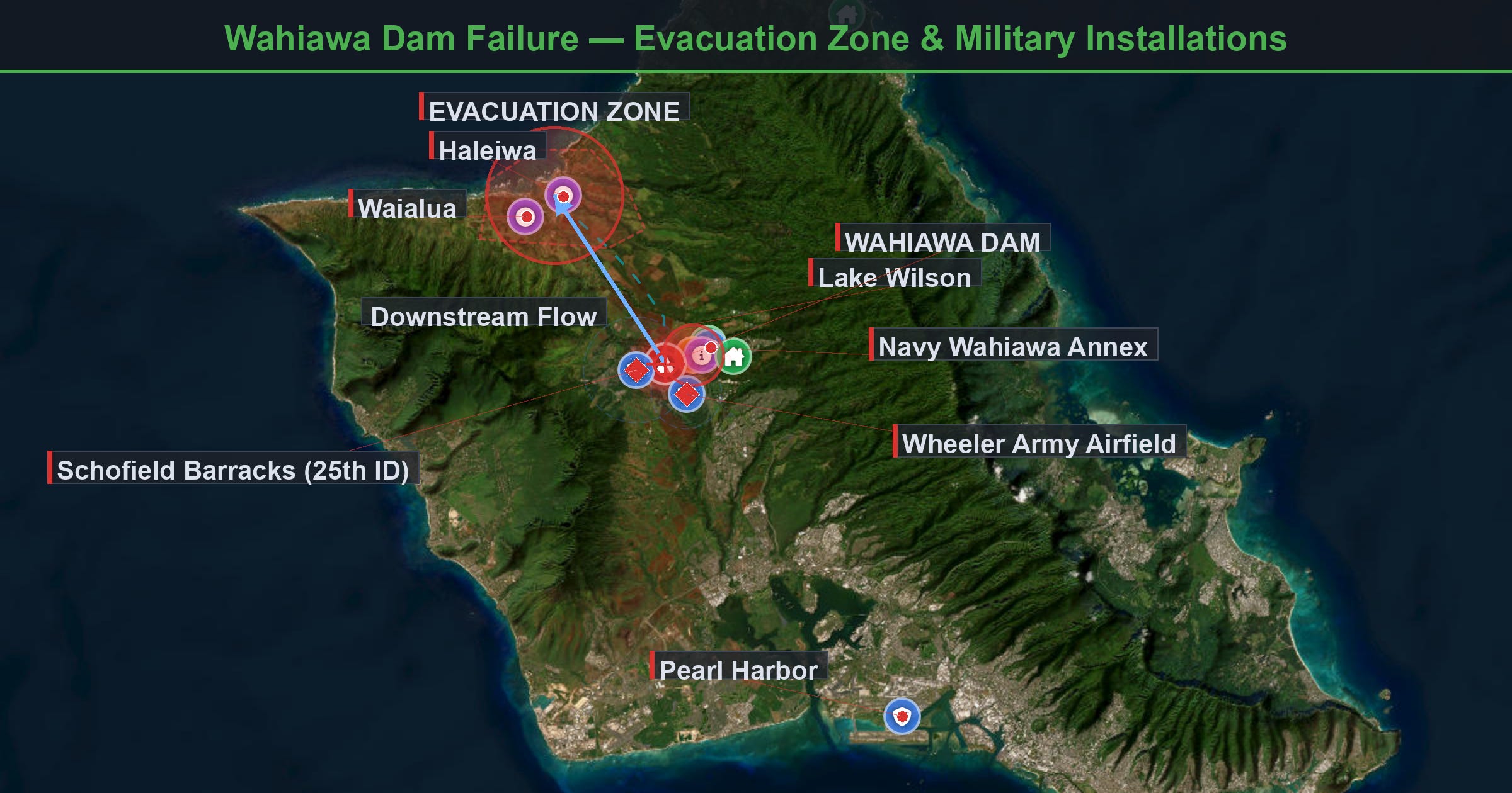
The alert, issued at 8:34 a.m. local time, warned of potential life-threatening flooding and catastrophic amounts of fast-moving water in the downstream areas of Haleiwa and Waialua on Oahu’s North Shore.
The dam has not breached as of Thursday morning, but water was pouring over the spillway at approximately 1,500 gallons per second after a second Kona low weather system dropped over 13 inches of rain in approximately 12 hours beginning Wednesday evening.
The National Weather Service (NWS) declared a Flash Flood Emergency, its highest-tier alert, covering approximately 138,000 people across northern Oahu.
Additional heavy rain bands are expected through Sunday, March 22, raising the possibility that conditions at the dam could deteriorate further before relief arrives.
This is the second evacuation event at Wahiawa Dam in March. The first Kona low, which struck Oahu from March 10 to 15, raised the reservoir to 82.8 feet and prompted an earlier evacuation notice that was lifted on March 14 after water levels stabilized.
The second system hit already-saturated ground and an already-elevated reservoir, creating a compounding effect that dam safety experts have warned about for decades.
The core vulnerability at Wahiawa Dam has been documented since 1978, when the U.S. Army Corps of Engineers first identified the spillway as undersized for extreme precipitation events.
Evacuation Zone and Emergency Routes
The evacuation zone covers all of Haleiwa between Puuiki Street and Kamehameha Highway, and areas of Waialua between Kukea Circle and Otake Camp.
The Oahu Department of Emergency Management designated the following evacuation route: Kamehameha Highway toward Wahiawa, onto Kamananui Road, then left onto Wilikina Drive.
Assembly areas are open at Wahiawa District Park, Leilehua High School, and Kahuku Elementary School. The Waialua High and Intermediate School assembly area is closed due to flood conditions in the area. Karsten Thot Bridge on Kamehameha Highway is closed, and all traffic is routed to Kamananui Road.
Authorities warned residents not to use Kaukonahua Road to access Wahiawa. Honolulu City buses are assisting with evacuations, and law enforcement is on-site to coordinate transport.
Both primary access routes to Haleiwa and Waialua are flooded, effectively cutting off these North Shore communities. Residents who have not evacuated face limited egress options if the dam condition worsens.
The geography of Oahu’s North Shore compounds this problem: the communities sit in a coastal plain between the Waianae and Koolau mountain ranges, with the Kaukonahua Stream drainage basin channelling all upstream runoff through the settled areas. In a dam failure scenario, floodwaters would follow these drainage channels directly through the evacuation zone before reaching the ocean.
 | A guest post by
|