
U.S. Coast Guard Leads Mass Rescue Operations in Flood-Impacted Western Alaska Communities
Hurricane-force winds and storm surges submerged homes and infrastructure in Kipnuk and Kwigillingok, requiring urgent evacuations amid ongoing recovery efforts.


Bering Sea Coast, Alaska — Since October 12, remnants of Typhoon Halong have triggered coastal flooding in remote Yukon-Kuskokwim Delta villages, displacing approximately 1,000 to 1,500 residents and prompting coordinated rescues by U.S. Coast Guard and Alaska National Guard units.
Hurricane-force winds and storm surges submerged homes and infrastructure in Kipnuk and Kwigillingok, requiring urgent evacuations amid ongoing recovery efforts.
The storm originated in the western Pacific, weakening into an extra-tropical system before making landfall. Initial assessments confirmed structural damage, with power outages and communication disruptions complicating early responses.
Coastal erosion and permafrost thaw contributed to impacts noted by officials in these Yup’ik communities. Aid deliveries continued into October 15, focusing on essentials like generators, canned food, and hygiene kits.
Regional airports reopened by October 14, improving logistics for further support. Searches for two missing individuals in Kwigillingok were suspended on the evening of October 14 without new casualties reported as of October 15.
Storm Overview
The event began with Typhoon Halong forming in the western Pacific, transitioning into an extratropical system that impacted Alaska’s Bering Sea coast on October 12.

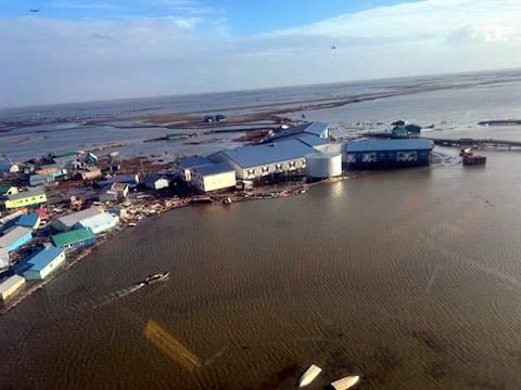
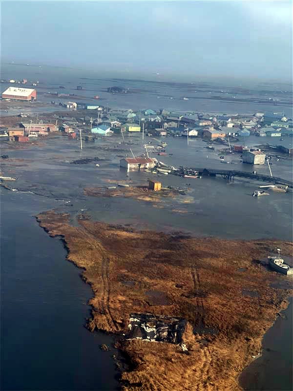
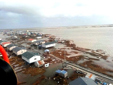
Total water levels in Kipnuk reached 14.5 feet (4.4 meters), exceeding major flood stages by more than two feet and surpassing the 2000 record. Kwigillingok experienced storm surges of 6.3 to 6.6 feet (1.9 to 2 meters) above mean higher high water, with gauge readings at 16.5 feet, breaking the 1990 record by over three feet (0.9 meters). Surge heights were linked to the storm’s intensity per National Weather Service records.
Both areas faced strong winds and overnight inundation, leading to damage. State troopers confirmed the impacts on October 12. The National Weather Service noted surge heights linked to the storm’s energy.
Communities endured prolonged exposure due to their isolation. Recovery assessments highlighted the role of elevated ocean temperatures in contributing to the storm’s intensity per meteorological records.
Impacts on Communities
Flooding displaced homes from foundations, inundated roads, and interrupted power in low-lying Yup’ik villages without road access or ample resources. At least eight homes were relocated in Kipnuk, four inundated in Kwigillingok, and 10 to 20 homes were affected in Napakiak, with fewer in Nightmute, contributing to dozens impacted regionally.
Runway cracks at Kipnuk’s airport hampered operations, while communication outages delayed responses. Coastal erosion and permafrost thaw, longstanding issues, contributed to the impacts noted by officials in Kipnuk and Kwigillingok.
Similar damage occurred in Kongiganak and Kotlik, with homes destroyed. Power outages lingered, straining fishing and hunting-based subsistence economies. Officials reported ongoing assessments of long-term needs for vulnerable residents. State officials noted the event’s scale exceeded recent precedents.
Disaster Declaration and Initial Response
 | A guest post by
|